Introduction
The south-east covers the area of Morecambe Bay as far south as Warton Crag in Lancashire and as far west as the Leven Estuary and then following the southern section of Lake Windermere up to the town of Bowness and then across to the town of Kendal, this large area I have already been exploring the area of Arnside and Silverdale area on previous missions, so I will not go over that area again.
So this mission will be using Alfred Wainwright's book the Outlying Fells to explore the rest of this area, by exploring this area will give me a better understanding of how the present Lake District fells have shaped the area beyond the main fells from the last Ice Age.
With covering a large area I would not have a base camp but living out of the van moving from place each day with my trusty travel companion Sam the dog.
27/07/16.
Arnside was my first stop over after coming off the motorway to spend the night on the promenade and I had a lovely calm sunny evening across the Ken Estuary looking across to Grange-over-Sands and Whitbarrow all upcoming mission over the coming days. And again in the morning a lovely morning of sunshine across the estuary.
 |
| Arnside |
Day 1 Beetham Heritage
Walk 7 miles.
As I reached the village of Beetham the clouds had rolled in and by the time I had left the Heron Corn Mill car park to set off on my walk it was overcast, I walked through the nice limestone village of Beetham
Limestone rock was to be the main rock over the coming days, away from the volcanic rocks of the fells, the Lake District is surrounded by a band of Carboniferous limestone.
Out of the village crossing pasture fields with sheep, you pass a granite boulder this was transported here during the Ice Age, it would have lain in a sheet of moving ice a glacier and deposited hear, the rock itself came from the Shap fells.
 |
| Beetham |
The next part of the walk took me through woodland, limestone woodland of hazel, ash, rowan and yew all growing on areas of limestone pavement, there was also plenty of Hart's tongue and Polypod ferns.
Out of woods and on the road to Slackhead where I spotted a male stag fallow deer in the woods. On through Slackhead and back into the woods, it was raining lightly now has I reached the Fairy Steps, a set of steps cut into the face of the small limestone cliff using natural features in the rock.
 |
| Fairy Steps |

On through the woodland to Haverbrack and out onto a short section of Kent Estuary in the light rain. I left the estuary and went to the
The last section of the walk back to the car park, despite the weather it’s still been a good walk with plenty of verity from limestone woodland to the estuary and into parkland.
Day 2 Whitbarrow Part 1
8 miles
Having spent the night at the foot of Whitbarrow in a layby on a small country lane I was eager to get out for a walk, but that the morning had produced a grey morning of low cloud, so not wanting to be on top of Whitbarrow without having good views, my second option was a circular walk around the bottom of Whitbarrow.Whitbarrow stands out in the surrounding landscape standing with a white west-facing scarp and an elevation of 215 m (705 ft) made of Carboniferous limestone of around 350 million years old.
I was walking on its eastern side through woodland with only brief glimpses of the cliff face. It was not till I started the climb over Whitbarrow that I got any views and the sun was now out, with the first warmth of sun I spotted a grayling butterfly warming up.
I loved the rugged limestone top of Whitbarrow with its sparse vegetation and wide open views north to the Lakeland fells, but it was over before I was back in the woods on its western side now these woodlands are much older than the large woodlands on its eastern side. These had the typical species of yew, hazel and ash.
 |
| Grayling |
I was now heading down to the valley floor through Witherslack Woods and onto Witherslack Hall. From Witherslack Hall there was a short section of road walking along the valley bottom, you get some great views of Whitbarrow. I left the road for a track to Mill Side village a lovely village and the end of the walk.
 |
| Chapel Head Scar |

Whitbarrow Part 2
6 ½ miles
After an hours rest I was back out, passing through Mill Side I started the climb up Whitbarrow through the woods and then through scrub to the top on this hot sunny afternoon. Whitbarrow is a National Nature Reserve and is managed by Cumbria Wildlife Trust.
As you follow the paths over the summit through the rocky grasslands and scrub trees, there were wide open views all around me, it was stunning beautiful and the trees of yew and juniper stood out because of the way the wind had sculpted them. There were small areas of heather also, this denote to more acidic soils. There are also limestone pavements and they have their particular species such as hart's tongue fern, and rigid buckler fern, and all around me was flowering harebell.
 |
| Limestone pavement. |
 |
| Sculpted Trees |
I made my way to the highest point known as the Lords Seat with great views all around, this is one place I must revisit in early summer and spend some time to study the plants.


From the Lords Seat, I made my to Witherslack Hall on the way down there were some great views and then it was back into the woods and then back to Witherslack Hall, with a repeat of the walk back to Mill Side and the end to the walk.
Evening Walk Newton
2 ½ miles
I had moved from Mill Side to Lindale village and had a few hours rest before coming up with this walk, what was only a short excursion up Newton Fell to Dixon Heights I knew this walk was going to have its problems before I started it, but did not realize how bad they were going to be.
Since AW put this walk together in the 1970s there has been some development such as the A53 bypass what cuts the beginning of route off, so I had to cross a busy road with caution and made it to the other side, this where it went wrong the public right of way was there, but AW wanted to go another way but the problem was there was no sign of it through tall bracken but I went on in the right direction fighting my way uphill through the bracken, after some hard work and determination I made it out of the bracken into a clearing, thinking this is a walk to do in winter when the bracken was down and not in the height of summer has I was doing.
It got better as I found a track and could see the ruined tower on the summit.On the summit I had a good rest, and enjoyed the good views.
Newton Fell is made up of slates, siltstones and sandstones, formed in the sea, during the Silurian period about 420 million years ago. These rocks are known to geologists as the Windermere Group.
 |
| Dixon Heights |
 |
| Whitbarrow from Dixon Heights |
The return route was at least better and then the crossing of the bypass again and back into the village.
Day 3, Newton
1¾ miles
Day 3 a lazy day after all the missions yesterday, I parked up next to the A53 near the Whitestone caravan site to do a small circular to take in Newton Fell north.
I went under the bypass, to pick up a footpath across fields to a minor road. You get a good view of the whole length of Newton Fell. A short section of road walking then from Byre Bank you pick a track up that takes you to the Bypass again and with a quick dash across the road to pick the track up again now climbing with views improving and easy going through the bracken but could not find the path to the summit of White Stones but found my return path through the wall and then more bracken to tackle down Newton Fell to the caravan site and the end of the walk.
The rest of the day was spent in Grange-over-sands relaxing, then I headed down to Humphrey Head for the night. Had a lovely evening there and had a good sunset.
 |
| Sunset |
Day 4 Hampsfell
3 ½ miles
This is one walk I have been looking forward to after reading good things about the area, so on a quiet early Sunday morning I had parked up on the main road next to Eggerslack Wood and walked into Grange-over-sands and through the town to head out on the Grange Fell Road all up hill, with nice views opening up across Morecambe Bay on this sunny morning, I turned off onto a track to Fell End up on fell end there are wide open views all around you. I sat there resting taking in the views. |
| Morecambe Bay from Fell End |
Hampsfell is an elevated ridge of limestone that looks over the Kent Estuary and it was along this ridge that I aimed for the summit what is crowned with a small building known as the Hospice. With wide open views around I first pass through grassland then onto limestone pavement under my feet, to reached the summit with all the joy in my heart on a beautiful summer’s day. The summit is 723 ft (220 m).
I first checked out the hospice with its steps leading to the roof and a view indicator and what a great view of the fells to be seen. I stayed some time on the summit.
 |
| Hospice |
From the summit I made my through a lovely area of limestone pavement and scrub with their stunted growth of trees on the pavement. As I slowly descended off Hampsfell and into the lovely woodlands of Eggerslack Woods.
This has been great walk one what I need to see again in spring or early summer to look into the plant life and butterflies. I was soon back at the car and the end of the walk.
 |
| Hampsfell skyline |

Humphrey Head
4 miles
Just to the west of Grange-over-sands isWainwright says: Fellwalkers need an occasional change of scene. Here on Humphrey Head.
 |
| Humphrey Head |
From the railway station, I took the path that is on the seaward side and followed this with the view being of flat salt marsh and Humphrey Head till I reached the headland and then into the woodlands that cover its eastern side and out into fields to Humphrey Head Point.

Where I had a short break then started the climb to the ordnance survey triangulation station, 171 feet (52 m), this is where the weather changed and I had my first shower. I soon came full circle and repeated my walk along the estuary back to the railway station. It’s been another nice walk, but it needs further investigation to find its secrets. Now I have found the main paths around this nature reserve I need to know when to visit it, and discover the flora.

Where I had a short break then started the climb to the ordnance survey triangulation station, 171 feet (52 m), this is where the weather changed and I had my first shower. I soon came full circle and repeated my walk along the estuary back to the railway station. It’s been another nice walk, but it needs further investigation to find its secrets. Now I have found the main paths around this nature reserve I need to know when to visit it, and discover the flora.
 |
| Humphrey Head Point |
Bigland Barrow
4 ¾ miles
I took the car up to |
| Observation tower |
 |
| Lake Windermere and Gummer's How |
The summit is 630 feet (190 m) is a good viewpoint and one I intend to visit again.
From the summit, I headed towards a tarn and through an area of bracken and lost my path around the tarn. It took some time to get back on course and a fair bit of country road walking and the walk was at the end.


It's been a good day of exploration and I was now tried from it and I took the van up to Gummer’s How car park for the evening, and was surprised with the view from the car park, the view looked up the valley that is Lake Windermere sits in. I decided to spend the night in the car park.
Day 5 Gummer’s How.
2 miles
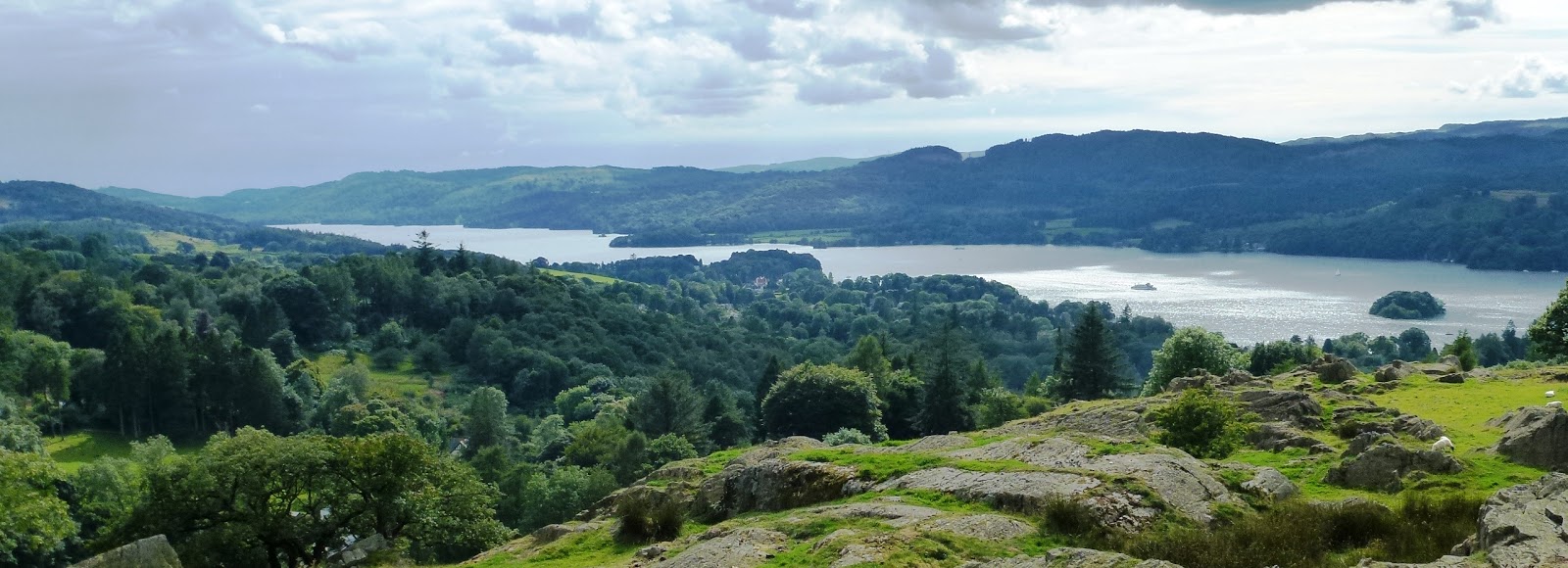
I was up nice early this morning and the sun was already out warming up the morning as I checked the car park view out again, before setting off for the little walk to the summit of Gummer’s How, within 30 minutes I was at the summit and enjoying the view up and down |
| Gummer's How summit |
 |
| Lake Windermere |
Staveley Fell, Cartmel Fell.
5 ½ miles
I had put two of Wainwrights walks together to make a bigger walk, and I used Gummer’s How car park as my starting point and set off through the wood to Sow How Lane you get a nice view from the lane looking south down the Winster Valley.
I left the lane for a bridleway to Sow How Tarn it was easy walking and a nice area to walk through I passed the tarn and onto Raven’s Barrow an open area of grassland I headed over to the monument and had my first break there.

I left the lane for a bridleway to Sow How Tarn it was easy walking and a nice area to walk through I passed the tarn and onto Raven’s Barrow an open area of grassland I headed over to the monument and had my first break there.

From the monument it was downhill into the woods and on to Foxfield and then you start to climb again with nice views south again, then I went into a plantation heading for Simpson Ground Reservoir. The path deteriorated when I started to look for a path for Staveley Fell the plantation what I had been going through came to end when I came to an area what been cleared felled and I could not find a path to the top through all the dead trees lying on the ground. So I gave up and I just finished my walk off, it's been a nice walk but for the last section.

Brant Fell
2 miles
After being out in the rural countryside for several days Bowness came of a bit of shock as I came into the town and was met by the hordes of tourists that was there, after some difficulty of finding a parking spot I found one and joined the tourists for the afternoon to look around Bowness but did not stop long feeling uncomfortable with so many people around me.
So this being my last walk of the day I was glad to be back out in the countryside on this small walk. Through fields and woodland, I was soon at the summit but I did not have it to myself, I sat there taking in the nice view with Lake Windermere dominating the view it was good, I had a good hour up here relaxing.
 |
| The lower reaches of Windermere |
 |
| The upper reaches of Windermere |
Then I headed back to the busy town of Bowness
Day 6 Scout Scar.
7 ½ miles
My last day and having spent the night in the car park at Scout Scar, not the quarry car park but the other car park.
This is one walk I was so looking forward to doing having read much on this limestone area, I took the car to Kendal and found a parking space near Serpentine Wood to start this circular walk.
Up through Serpentine Wood, an interesting woodland for its flora, so a springtime mission to visit. You leave the woodland for the open ground of the golf course with views down to the town of Kendal
It's here where the bypass cuts through the limestone you get a good view of the limestone known as Park Limestone. on the other side of the bypass, the footpath continues onto Cunswick Fell to the summit, I take my first break at the large cairn of Cunswick Fell and enjoyed the view to the ancient eroded volcanoes of the Lake District .
From the summit I came to Cunswick Scar a limestone edge that I followed for a short distance, through fields and scrub to the car park I stopped in last night.
 |
| Cunswick Fell |
A short section of road walking and then the path to Scout Scar escarpment with stunning views around me I made my way to the shelter known as the Mushroom and there I had another rest. Scout Scar is 771 feet (235 m).
 |
| Mushroom |
Then it was back along the escarpment for another mile of stunning landscape views along the route checking the flora and enjoying the long distance views.
the path took me away from the edge and across some stunning scrub landscape.
heading now back to Kendal. I can see myself coming back to this walk again to discover its secrets. The last part of the walk was road walking back into Kendal.

the path took me away from the edge and across some stunning scrub landscape.
heading now back to Kendal. I can see myself coming back to this walk again to discover its secrets. The last part of the walk was road walking back into Kendal.
 |
| Escarpment |

Geology and history
The coast of Morecambe Bay has not always looked like does today from the end of the Ice Age to the Roman Period there have been marine transgressions, this where the sea level rises relative to the land and the shoreline moves toward higher ground, resulting in flooding. There is evidence that at least six marine transgressions, of varying intensity, affected the coasts. Whitbarrow is one example where the shoreline would have been and Humphrey Head would have been an island.
The limestone of the area also has caves and evidence of human activity comes from Kirkhead Cave near Grange-on-Sands and appears to have been occupied during the Upper Palaeolithic Period around 10,000 years ago.
This has produced artefacts defined typologically to this period, while three Palaeolithic-type blades have been claimed from Lindale Low Cave to the North-east of Kirkhead, near the entrance of the River Kent. This gives evidence of early hunters exploiting the megafauna of the tundra landscape on the edge of the retreating ice.
There is a certain amount of evidence that the caves around Morecambe Bay witnessed continued occupation during the Mesolithic period, such as the Whitbarrow Bone Cave on Whitbarrow which revealed faunal remains.
Final words
I known now that after exploring a few of these sites that there was to be revisits back to explore them more in detail, when not knowing the area to be explored it is difficult sometimes to find somewhere to park, or what state the paths are in or if there are any paths at all, what is the best month to visit, to find what you want to see, and timing it with the weather, these are all things to think about. But now I am getting a better understanding of this area and it’s so different from my main walks of the Lakeland
A new word came up on several of my walks allotment. The term 'allotment' is not used in the modern sense of plots for individuals to grow vegetables in, but land that fell within the bishops power to allocate for grazing or cultivation.
A new word came up on several of my walks allotment. The term 'allotment' is not used in the modern sense of plots for individuals to grow vegetables in, but land that fell within the bishops power to allocate for grazing or cultivation.